Historical Landmarks
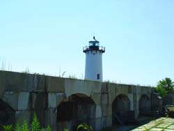
Fort Constitution
Off Route 1B at the U.S. Coast Guard Station
New Castle, NH
Phone: 603-436-1552
Description: It overlooks both the Pisquatua River and the Atlantic Ocean.
In 1791, the State of New Hampshire gave the United States the neck of land on which Fort William and Mary and a lighthouse were situated. The fort was repaired, renamed Fort Constitution and garrisoned with a company of United States artillery. Renovations, which included a wall twice as high as that of the colonial fort and new brick buildings, were completed in 1808. It is the ruins of this fort that are seen today.
Location: Located off Route 1B at the US Coast Guard Station
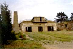
Fort Stark
Off Route 1B, Wildrose Lane
New Castle, NH
Phone: 603-436-1552
Description: Fort Stark was named in honor of John Stark, commander of N.H. forces at the Battle of Bennington (1777).
An unmarked walking trail traverses the ten-acre fort site. There are no camping facilities.
Please visit with caution! Fort Stark is a former military installation. Beware of dangers of unprotected stairs, high walls, rough ground and slippery rocks. Adult supervision of children is required.
The old machine shop at the Fort Stark State Historic Site contains exhibits relating to the military history of New Castle, NH (specifically the 22nd coastal artillery which was stationed there in World War II). An entire section of the museum is dedicated to shipwrecks which occurred in the New Castle area. A picnic area and nature walk are also at the site. There is an area to launch kayaks, a small beach and fishing is allowed.
Location: Located off Route 1B on Wildrose Lane
Camp Stark German Prisoner of War Camp
Route 110
Stark, NH
Marker Number: 150
Name and date established: Stark 1985
Description: In the spring of 1944 a high fence and four guard towers transformed a former Civilian Conservation Corps Camp on this site into New Hampshire's sole World War II prisoner-of-war camp. About 250 German and Austrian soldiers, most of whom were captured in North Africa, lived in Camp Stark while working in the surrounding forest where they cut pulpwood vital to wartime industry. The camp closed in the spring of 1946 when the prisoners of war were returned to their homeland. Several maintained the new friendships they had formed with local New Hampshire residents.
Location: Located on the south side of Route 110, about 1.6 miles east of the Stark Covered Bridge.
